
Living Labs
We shape innovative transportation projects in user-driven test environments—real-world challenges, real data!

6 Countries
FORTHCOMING makes use of its varied case studies, belonging to 6 countries: Spain, Hungary, Italy, Germany, and Türkiye. The case studies are low-to-mid-density and either belong to Mission Cities partner cities’ metropolitan areas (Madrid, Turin, Lisbon, Istanbul) or relevant cities that are outshone by capital cities or economic centers and that nonetheless are of interest (Hamburg, Debrecen). These case studies cover Europe’s vast geography, representing different climates, cultures, and wealth. All case studies include the central city (core city) where several 15-minute city-aligned strategies are already implemented or planned, and either a periphery area or a city in the suburbs (suburb setting) where those measures will be transferred.
The 6 Case Studies
The 6 case studies are all selected according to the following logic: One core city with 15-minute city measures being implemented and a suburban city/area in the metropolitan area in need of improvement where Urban Living Labs (ULL) will be set up. The ULLs will allow us to define a common approach for all 6 Case Studies as well as define a methodology for testing innovations and involving citizens and stakeholders like public authorities, transport operators, technology providers, and community associations.


Hungary
Debrecen ULL: Kertváros
About Kertváros
Kertváros is Debrecen’s green belt, home to 70,000 residents. It is a mainly residential area with single-family homes and some high-rise estates. Retail trade dominates the local economy.
Mobility & Safety
-
Cycling is on the rise, supported by 108 km of bike paths citywide, 21.6 km in Kertváros.
-
Pedestrian safety enhanced by traffic calming, 30 km/h zones, and new residential/recreational areas.
Challenges
-
Few local jobs & services → reliance on central Debrecen
-
Low density → long walking distances
-
Limited last-mile & shared mobility options
-
Rising motorisation
-
Housing affordability pressures

Kertváros- Cycling network
Kertváros- Proximity by walking: Trams
Opportunities
-
Supportive city strategy aligned with the 15-minute city principle
-
Low vehicle traffic, making active mobility viable
-
Compact urban development goals to reduce sprawl
Accessibility Insights
-
Limited walking access to tram (15%), train (23%), and public spaces (35%)
-
Essential services are accessible, but many subcategories (e.g. pharmacies, dentists) lack adequate coverage
-
In smaller cities like Debrecen, shorter walking benchmarks than 15 minutes may be more realistic
Germany
Hamburg ULL: Lurup
About Lurup
Lurup is a growing residential district in northwest Hamburg’s Altona, bordering Schleswig-Holstein. Once shaped by industry, it now mixes single-family homes, mid-rise apartments, quiet streets, shops, and recreational spaces. Population growth is accelerating with new urban developments.
.jpg)
Key Challenges
-
Limited public transport: no U-Bahn, indirect S-Bahn, long bus connections
-
Barriers: heavy-traffic roads (A7, Luruper Hauptstraße) and rail infrastructure divide the district
-
Weak cycling network and few city bike stations
-
Fragmented planning and regulatory hurdles slow progress
-
Risk of gentrification as demand for affordable housing rises
Opportunities
-
New housing & amenities: mid-rise projects with better transport links now emerging
-
Leverage MOVE21 pilot: multifunctional hubs combining social services, youth support, and last-mile e-cargo bike logistics
-
Compact scale (6.3 km²): high density and proximity make walkable solutions viable
Accessibility Insights
-
High walking proximity to most daily services (>90%)
-
But walkability and cycling gaps persist
-
Luruper Hauptstraße remains a major barrier street, dividing communities and key POIs (schools, LURUM, churches)
-
Bus lines often prioritise central Altona, leading to longer waiting times for Lurup residents

Lurup - Proximity by walking: Public Transport
Lurup's cycling infrastructures

Türkiye
Istanbul ULL: Küçükçekmece
About Küçükçekmece
Located 15 km west of Istanbul’s historic core, Küçükçekmece is a densely populated district anchored by its namesake lake. With 93% of land use residential, it is characterized by mass housing, commercial hubs, and logistics activity. Its position near E-5, TEM, Basın Ekspres, rail lines, and the airport makes it a strategic mobility and freight corridor.
-
Key Challenges
-
Severe traffic congestion, including logistics flows
-
Poor pedestrian environment: substandard sidewalks, unsafe crossings
-
Very limited cycling infrastructure
-
Pressure on services from high density
-
Scarcity of greenery in built-up zones
-
Social inequalities and spatial segregation
Opportunities
-
Strong connectivity through extensive public transport
-
Potential to promote cycling culture, especially along the seaside
-
New green public spaces planned near the lakefront
-
Stakeholder partnerships for zero-emission urban freight & last-mile delivery
-
Integration with the 3D Istanbul Project

Küçükçekmece- Proximity by walking: Getting supplies
Küçükçekmece- Proximity by walking: Public Spaces.
Accessibility Insights
-
High proximity to leisure, healthcare, education, and public transport thanks to density and network coverage
-
Notable green anchors: Lagün Park, Göl Sahil Park, Şeyh Şamil Park, plus neighborhood parks (Begonya, Günışığı, Rıza Bayat, Cihan Caddesi, Ulubatlı Hasan, Nehir)
-
Despite these, greenery remains scarce in the built environment
-
Access to public spaces is very low (14.5%), exposing gaps in urban design
-
Proximity varies by neighborhood:
-
Northern side: modern housing + recreational spaces (Atakent)
-
Southern side: older, denser residential areas (Kanarya, Cennet, Yenimahalle, Sultan Murat) with weaker service access
-
Portugal
Lisbon ULL: Alverca do Ribatejo
About Alverca do Ribatejo
Situated in Vila Franca de Xira near Lisbon, Alverca do Ribatejo combines residential, commercial, and industrial areas structured around transport corridors. The A1 motorway cuts through the municipality, separating industrial zones near the river from residential and agricultural areas inland. Urban services are concentrated in two former parishes, creating a fragmented urban fabric with both mid-density apartments and low-density housing.

Key Challenges
-
Spatial segregation caused by railway and road infrastructure
-
Weak internal mobility: poor links between commuter rail stations and residential areas
-
Services split between two urban centres (former parishes) → uneven access
-
Limited active mobility infrastructure
Opportunities
-
Strong political commitment to sustainable mobility and community well-being
-
Ongoing urban regeneration projects, especially at the riverfront and town centre
-
Plans to enhance public space quality and transport accessibility for youth and vulnerable groups
Accessibility Insights
-
Less than 50% walking proximity to most POIs, public spaces, and green areas
-
Only 57% proximity to public transport (bus stops, train stations)
-
Contributing factors:
-
Large forested area without road access
-
A1 motorway acting as a barrier
-
Services divided between two former parishes
-

Alverca do Ribatejo - Proximity by walking: Getting supplies
Alverca do Ribatejo - Proximity by walking: Enjoying

Spain
Madrid ULL: Las Rozas
About Las Rozas
Located 20 km northwest of Madrid, Las Rozas is a low- to mid-density municipality with nearly 100,000 residents. It has expanded rapidly through car-dependent urban sprawl, featuring large commercial hubs and a business park. The Living Lab area spans the historic centre and two newer residential zones—Burgo-Centro/Cornisa/Yucatán and La Marazuela—divided by highways and railways. Higher-than-average incomes and fast growth have intensified mobility pressures.
-
Key Challenges
-
Spatial segregation from 3 major highways
-
Limited active mobility infrastructure
-
Rapid population growth and sprawl
-
Poor walking access to train stations (11%)
-
Heavy car use → unsafe cycling, delays in public transport, barriers to BRT development
-
Risk of retailer backlash to traffic calming / pedestrianisation measures
-
Opportunities
-
Existing pedestrian areas and new cycling lanes
-
Positive economic impact of pedestrian zones on local commerce
-
Wide range of public transport options
-
Potential to reconvert unused carparks and free space
-
Current LEZ regulations allow flexibility for work vehicles

Las Rozas- Proximity by walking: Getting supplies
Las Rozas - Proximity by walking: Public Spaces
Accessibility Insights
-
Strong walking proximity to green spaces (78%), leisure, healthcare, and education
-
Major accessibility gaps:
-
Public spaces (8.6%)
-
Train stations (11%)
-
Workplaces (37%)
-
Supply services (35%)
-
-
Accessibility concentrated in the historic centre with compact urban form and mixed-use amenities
-
Outlying areas (e.g., Monterrozas, Punta Galea) face long distances and barriers due to low density and transport infrastructure

Italy
Turin ULL: Settimo Torinese
About Settimo Torinese
Located 10 km northwest of Turin, Settimo Torinese is the third largest municipality in the metropolitan area, spanning 35.6 km². Its economy is diverse—industry, logistics, and retail—and it has become a major shopping destination. The historic centre retains traditional street patterns, while surrounding areas feature planned residential developments, green spaces, and designated industrial zones along key transport corridors. Strong road and rail links connect it to Turin, with significant commuter flows.
-
Key Challenges
-
Spatial barriers: A4 and A55 highways, rail lines, industrial areas, SP11, and Po River
-
Weak integration of public transport policy (no metro, limited train expansion)
-
Heavy traffic congestion due to car dependency
-
Poor cycling network (16.4 km only) and limited last-mile connections to industrial areas and transport hubs
-
Governance bottlenecks and fragmented planning
-
Limited funding and insufficient public facility maintenance
-
Risk of local polarisation and lack of consensus on interventions
-
Opportunities
-
Good distribution of schools → potential anchors for multifunctional neighbourhood hubs
-
Build consensus around health and environmental benefits of interventions
-
Established public consultation processes:
-
12 open forums annually
-
Dedicated consultations with associations (e.g., elderly groups)
-
3 days/year youth consultations (<25 years)
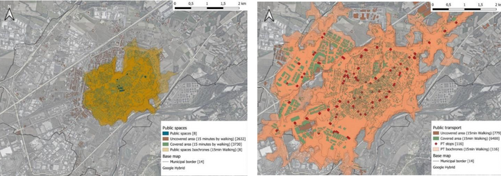
Proximity to public spaces by walking in Settimo Torinese
Proximity to public transport by walking in Settimo Torinese
Accessibility Insights
-
High walking accessibility to most POIs, though not accounting for pedestrian infrastructure quality (e.g., sidewalks, crossings, accessibility features)
-
Lower access to public transport and public spaces compared to other ULLs
-
Cycling network underdeveloped and fragmented, especially along provincial roads
-
Last-mile gaps to industrial areas and train stations limit sustainable commuting options
-
Walkability and public space renewal are key priorities for future projects
Updates


